
March 2024
- English
- 日本語
Kesennuma Bay Crossing Bridge: A Symbol of Tohoku Reconstruction
-
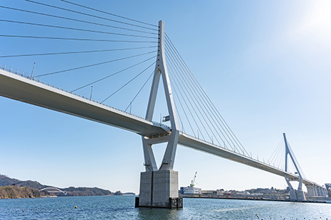
The magnificent Kesennuma Bay Crossing Bridge spans Kesennuma Bay (Miyagi Prefecture) with a total length of 1344 meters. -
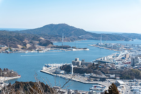
Kesennuma Bay landscape (Kesennuma Bay Crossing Bridge slightly to upper right)
-
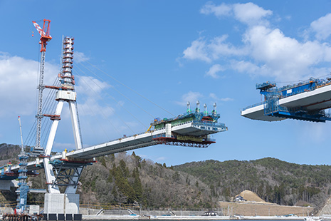
Kesennuma Bay Crossing Bridge under construction -
The Kesennuma Bay Crossing Bridge is characterized by its smart design. -
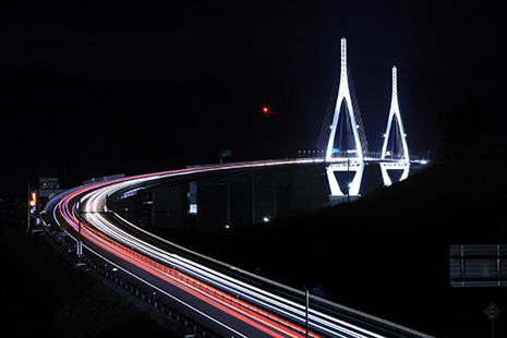
Kesennuma Bay Crossing Bridge illuminated at night
The Japanese government has progressed with the development of the Kesennuma Bay Crossing Bridge (nicknamed 'Kanae Ohashi'), as a leading project for reconstruction following the Great East Japan Earthquake that occurred on March 11, 2011. Here, we provide an overview of the bridge.
Kesennuma Bay, located in Kesennuma City in the northeastern part of Miyagi Prefecture, faces the Pacific Ocean. The bay is divided into the eastern bay and western bay by Oshima Island (also known as Kesennuma Oshima) situated in the central part of the bay. Kesennuma Port, nestled in the depths of the western bay, is a natural harbor renowned for its abundant catch of bonito, Pacific saury, and sharks, making it one of Japan's leading fishing ports. Aquaculture of oysters, wakame seaweed, and sea squirts is also conducted, capitalizing on the unique coastal terrain of the ria coastline.
In March 2011, the Great East Japan Earthquake occurred, triggering a massive tsunami and subsequent large-scale fires, which dealt a devastating blow to the lives and industries of the people in Kesennuma City. In response, the Japanese government, in collaboration with prefectural and municipal authorities, formulated various reconstruction plans. Among these initiatives was the construction of the Kesennuma Bay Crossing Bridge.
According to the Construction Division of the Ministry of Land, Infrastructure, Transport and Tourism's Minamisanriku National Highway Office, the project began in 2012. Initially, the focus was on selecting the route for the bridge, with a staff member emphasizing, "We conducted thorough investigations, taking into account the opinions of the local community."
As a result, the construction of the bridge on the seaward route crossing Kesennuma Bay was decided, and the actual design process commenced. "When determining construction type for the bridge, we prioritized measures against natural disasters such as earthquakes and tsunamis. In addition, we ensured that the bridge's placement would not obstruct rich fishing grounds or aquaculture sites. We also aimed to harmonize the design and color scheme with the surrounding natural environment."
A simple design that harmonizes with the surrounding landscape was adopted. The land portion was to consist of a typical steel box girder bridge*, while the sea portion was planned to be constructed as a cable-stayed bridge spanning the sea, supported by two main towers. "One of the distinctive technical features of the Kesennuma Bay Crossing Bridge is the implementation of a novel design method called 'Damage-Control Design.' Even in the event of disasters such as storms, earthquakes, or tsunamis, the bridge is expected to serve as an emergency transport route. So, careful analysis and examination of potential damages caused by such disasters were conducted on each component of the bridge, aiming to transform unexpected damage into anticipated outcomes."
The bridge, spanning the Kesennuma Bay, was constructed by integrating insights gained from past experiences into cutting-edge technology, and stretches for 1344 meters. The nickname 'Kanae Ohashi' was chosen from names submitted by the public. 'Kanae' comes from the word 'Kanaeru' in Japanese, which means to fulfill hopes, dreams, and wishes. The bridge opened on March 6, 2021. This has led to the full opening of the approximately 126km extension of the 'Reconstruction Road'** in Miyagi Prefecture being developed as part of the reconstruction efforts. It is also anticipated to contribute to the future development of local industries.
In 2021, which marked the 10th anniversary since the Great East Japan Earthquake, the bridge opened as a symbol of reconstruction. Its nighttime illumination has also received positive feedback, turning it into a new landmark for Kesennuma. It will no doubt continue to play a significant role in the development of not only Kesennuma City but also the entire Tohoku region.
* A bridge constructed by assembling steel materials into a box-shaped cross-section to form the girder. A girder bridge consists of a roadway deck for vehicles and pedestrians to pass over, supported by main girders.
** Refers to the collective name for the Sanriku Coastal Road network (Sanriku Longitudinal Expressway, Sanriku North Longitudinal Expressway, and Hachinohe-Kuji Expressway), which was opened in 2021. It connects the coastal area from Hachinohe City, Aomori Prefecture, to Sendai City, Miyagi Prefecture.