Home > Highlighting JAPAN > Highlighting Japan September 2016 > Japan’s Fight Against Global Warming
Highlighting JAPAN
ALOS: Monitoring the Forests Above the Clouds
Japan is utilizing its space technology to support the conservation of the Amazon and other tropical forests in order to suppress CO2 emissions.
One factor in the global increase in carbon dioxide (CO2) emissions is the worldwide decline of forests, which have the function of absorbing and storing CO2. In an effort to suppress this decline, Japan is engaged in a number of overseas projects. One such project is the conservation of the Amazon rainforest using satellite imaging. The Amazon is the world’s largest tropical rainforest, spanning a region that lies across eight different countries, including Brazil and Peru. However, the Amazon rainforest has been rapidly diminishing in size since the 1960s due to deforestation and land reclamation for purposes such as road construction, logging for lumber, grazing land and soybean cultivation. Since 2004, the Brazilian government has been advancing various countermeasures in order to improve this situation. One initiative is a clampdown on illegal deforestation that includes monitoring of illegal logging activities by satellite imaging using optical sensors. However, this satellite surveillance has not been without flaws. Because optical sensors detect light reflected or emitted from the ground and convert it into images, they cannot create images of the ground from space when there is heavy cloud cover. It had therefore not been possible to discern the situation on the ground during the rainy season between October and March, when the Amazon region is covered by cloud, and there was a trend for illegal logging to increase during this season.
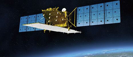
The piece of technology that has been instrumental in overcoming that flaw is the Advanced Land Observing Satellite (ALOS) launched by the Japan Aerospace Exploration Agency (JAXA) in 2006. ALOS is equipped with a Phased Array-type L-band Synthetic Aperture Radar (PALSAR), which uses microwaves that penetrate even through cloud cover, enabling monitoring of the ground even from above the clouds.
In addition, while the satellite that was being used previously only allowed surveillance data for ascertaining the logging situation in the Amazon rainforest to be obtained a few times a year, with ALOS it had become possible to analyze new monitoring data for the entire Amazon region every forty-six days, regardless of the season.
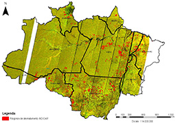
Utilizing these features of ALOS, between 2009 and 2012, the Japan International Cooperation Agency (JICA) carried out the “Utilization of ALOS Images to Support Protection of the Brazilian Amazon Rainforest and Combat against Illegal Deforestation” project in cooperation with the Brazilian Institute of Environment and Renewable Natural Resources (IBAMA) and the Federal Police. IBAMA analyzes satellite data together with Brazil’s National Institute for Space Research (INPE), and monitors and busts illegal logging operations in collaboration with the Federal Police. JICA dispatched remote sensing experts to advise IBAMA, and provided them with image analysis techniques and various other technologies. The activities of projects such as this along with the Brazilian government’s efforts have contributed greatly to the conservation of the Amazon forest. During the project period, approximately 2,000 instances of illegal logging were detected. The area of deforestation in 2014 was 500,000 hectares, more than an 80% reduction on the 2.7 million hectares recorded in 2004.
Operation of ALOS-2 began as of 2014, as a predecessor to ALOS, with further enhanced observational capabilities. An Amazon forest conservation project using ALOS-2 images was also launched in Peru in 2015.
“The sensor capabilities of ALOS-2’s radar for detecting activity in the forests are far superior to those of other satellite radars,” says Kenichi Shishido, deputy director general of JICA’s Global Environment Department. “Countries around the world have very high expectations for ALOS-2.”
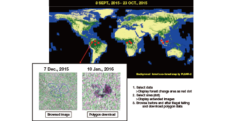
At the Japan Pavilion of the 21st Conference of the Parties to the United Nations Framework Convention on Climate Change (COP21) held in Paris, France in December 2015, JICA and JAXA presented a joint initiative entitled “Initiative for Improvement of Forest Governance.” This initiative will contribute to the protection of the world’s tropical forests through the development of a tropical forest monitoring system that will constantly monitor logging and deforestation of tropical forests around the world using ALOS-2.
Monitoring results will be announced publicly on the JAXA website approximately once every 1.5 months on average. This will enable even the general public, for example, to view the satellite images for themselves via their own smartphones. Trial operation is scheduled to begin in November 2016. JICA and JAXA have also announced that they will be training around 500 personnel from developing nations by 2020 in order to achieve widespread use of the system.
“Showing satellite images to the public allows everyone to see the status of deforestation, and will hopefully control illegal logging by improving transparency,” says Shishido. “Through this initiative, JICA will endeavor to improve forest governance in various countries and contribute to forest conservation.”


No article or any part there of may be reproduced without the express permission of the Cabinet Office. Copyright inquiries should be made through this form.
© 2009 Cabinet Office, Government of Japan