Home > Highlighting JAPAN > Highlighting Japan APRIL 2012 > AuthaGraph World Map Offers New Perspective
Highlighting JAPAN
SCIENCE
AuthaGraph World Map Offers New Perspective
Like the world maps that we are used to seeing, the continents are framed neatly in a rectangle, but a closer look reveals slight differences in their shape and position. This is the revolutionary new "AuthaGraph World Map," created by Hajime Narukawa of AuthaGraph Co. Masaki Yamada introduces the new map.
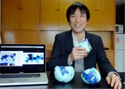
Hajime Narukawa, inventor of AuthaGraph, holds a paper globe made to understand the structure of AuthaGraph. The monitor shows the Mercator map (left) and Dymaxion map.
Credit: MASAKI YAMADA
"On the Mercator map the landmass size is magnified and increasingly distorted the higher the latitude. This is because the closer you get to the south and north end of the Earth, it becomes impossible to draw a flat surface without elongating the landmass. As such, landmasses such as Antarctica and Greenland look far larger on the Mercator map than their true land size."
In order to compensate for this flaw, various attempts have been made to produce new world maps. Of these, the latest map is the Dymaxion map published in 1946 by the American architect Buckminster Fuller. The advantage of this world map was that it showed landmass shape as accurately as possible, with less distortion. However, it jagged edges that break up ocean areas.
In the first place, it is mathematically impossible to perfectly draw the surface of a spherical body on a flat surface. However, Narukawa had the new vision of creating a map that would have minimal distortion as well as be able to fit within a rectangular plane.
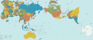
AuthaGraph World Map
Credit: AUTHAGRAPH
After the AuthaGraph was completed, it was the Japanese astronaut Mamoru Mori who expressed strong interest in this revolutionary new world map. This was because Earth as drawn on the AuthaGraph World Map, with no top or bottom, closely resembled Mori's view of Earth from the space shuttle. In June 2011, the AuthaGraph World Map was used as the "new standard in world maps" in place of the Mercator map in the Tsunagari Project of Japan's National Museum of Emerging Science and Innovation (Miraikan), of which Mori is the director. Further, as a result of Mori's recommendation, the Japan Science and Technology Agency (JST) distributed the AuthaGraph World Map to elementary, junior and senior high schools all over Japan. Moreover, in 2015 it is planned to include the AuthaGraph World Map in senior high school geography textbooks.
"The AuthaGraph World Map can be used as a map that centers on polar regions not only as a sea route chart but also for research into the ozone hole and for oil field development. On the other hand, the latitude and longitude on the Mercator map are drawn vertically, which makes it good for showing local time zones. In the future, I would like to gradually enhance the visibility of the AuthaGraph World Map by displaying it at exhibitions overseas and informing the younger generation, such as students, about the map. In this way, the two maps can be used according to the desired purpose," says Narukawa.


No article or any part there of may be reproduced without the express permission of the Cabinet Office. Copyright inquiries should be made through this form.
© 2009 Cabinet Office, Government of Japan